
The National Weather Service is warning of high waves and strong rip currents. (Courtesy of National Weather Service)
Hurricane Erin will lash coastal Cape May County with flooding, strong winds and treacherous surf as the storm grows even more dangerous than originally thought, according to the updated forecast by the National Weather Service.
The Cape May County Office of Emergency Management said the hurricane will pass to the southeast and east hundreds of miles offshore on Thursday, but is expected to expand in size, resulting in greater impacts to the coast.
Widespread minor to moderate coastal flooding is forecast for the high tides from Thursday evening through Friday evening. Locally, major coastal flood impacts are possible in Cape May County, as well as Kent and Sussex counties in Delaware.
The National Weather Service in Mount Holly, N.J., has issued Coastal Flood Warnings for Cape May County. Forecasts indicate a peak surge of 1 to 3 feet in the Delaware Bay, which may impact low-lying areas of bayside communities in Middle Township, Dennis Township and surrounding areas.
The highest risk of flooding will occur during the Thursday evening high tide at approximately 8:30 p.m., when tide levels are forecast to reach 6.5 feet above Mean Low Water (MLW).
Residents in flood-prone areas should take immediate precautions, said Cape May County Board of Commissioners Director Leonard Desiderio, who also serves as mayor of Sea Isle City.
“If you live in a low-lying area prone to flooding, please take the appropriate precautions now. Move your vehicles to higher ground and secure outdoor furniture and other items that could be damaged or carried by water or wind,” Desiderio said in a statement.
Motorists should avoid driving through floodwater, as road closures are possible during peak tides, Desiderio said.
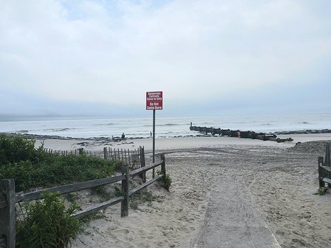 With the storm brewing, a red "Do Not Swim Here" sign has been placed at the entrance to the 10th Street beach in Ocean City.
Cape May County shore towns from Ocean City to Cape May have already been warning the public of flooding, high winds and treacherous surf conditions.
The forecast calls for the highest tide levels Ocean City and neighboring Upper Township have experienced in the past three years, peaking on Thursday evening. The storm coincides with the approach of higher tides from a new moon, Ocean City said in a weather alert.
Water levels are predicted to crest in the hours around high tide on the bay side (Ninth Street Bridge) of Ocean City at 7:50 p.m. Thursday. High tide on the bay side of Strathmere near Corson’s Inlet is at 7:35 p.m. Thursday.
In Ocean City, the National Weather Service predicts a water level of 6.7 feet on the mean low water scale. By comparison, the water level reached 5.88 feet MLW on Monday (Aug. 18), 5.2 feet MLW on Tuesday (Aug. 19) and a record 9.31 feet MLW during Superstorm Sandy (Oct. 29, 2012).
Visit www.ocnj.us/octides to compare this prediction to other recent and historic tide levels.
The hurricane will also generate sustained winds hovering at 25 mph to 35 mph, with gusts climbing to 50 mph. Ocean waves 10 to 17 feet high are expected offshore Thursday and Thursday night, creating dangerous conditions for boaters, according to the forecast.
Rough surf and a risk of strong rip currents will create “life-threatening conditions” in the ocean, the Cape May County Office of Emergency Management said.
“We’ve seen rough seas from strong northeast winds all week, and the waves will only get bigger and stronger as the storm approaches and passes by New Jersey on Thursday,” Ocean City Mayor Jay Gillian said in a statement.
 Ominous black storm clouds hover over the Ocean City Boardwalk.
Shore towns in Atlantic and Cape May counties have already announced outright swimming bans or other restrictions for beachgoers through Friday.
In another major impact, the forecast says that significant beach erosion is possible, caused by the heavy surf pounding the shoreline.
The Cape May County Office of Emergency Management will continue to monitor conditions in concert with the National Weather Service and provide updates as needed.
For the latest official forecast information, visit the National Hurricane Center at www.nhc.noaa.gov or the National Weather Service, Mount Holly, at www.weather.gov/phi.


