
More dangerous winter weather is in the forecast, just as the Boardwalk in Ocean City and other areas of South Jersey have barely recovered from the snowstorms in January. This photo of the Boardwalk is from Jan. 26.
And you thought it was time to put away those snow shovels?
Despite a warming trend this week, harsh winter weather consisting of heavy snow, coastal flooding and high winds is expected to come roaring back for the weekend.
Up to a foot of snow is possible on Sunday and Monday during what the National Weather Service is warning could be a “significant winter storm.”
Snowfall is expected to exceed 6 inches in many locations of New Jersey. But there is a growing possibility the storm will blanket the Cape May County shore area with 8 to 12 inches of snow. The Atlantic City area may get hit with 6 to 8 inches of snow, according to the forecast.
A Winter Storm Watch has been issued for all of New Jersey. At the shore, the storm watch is in effect from Sunday morning to 6 p.m. Monday
Precipitation is expected to begin on Sunday, continuing into Sunday night and Monday morning before tapering off on Monday afternoon.
“Snow accumulations are expected to exceed 6 inches in many locations, which could lead to extremely hazardous and dangerous travel conditions. These conditions are likely to impact the Monday morning commute,” the weather service’s Mount Holly office said in a statement.
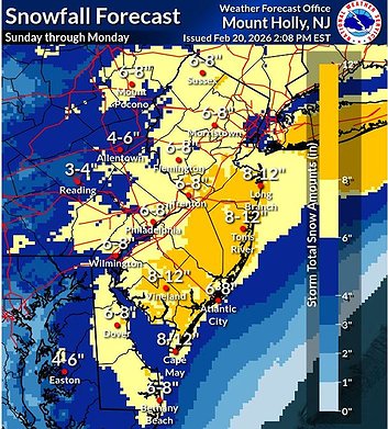 Snowfall amounts could range from 6 to 12 inches throughout South Jersey and the coastal areas. (Courtesy of National Weather Service)
Strong northeast winds will begin to increase on Sunday and persist through Monday, possibly into Monday night. Wind gusts of between 35 mph to 40 mph are possible along the coast.
Adding to the misery will be flooding at the shore in Atlantic and Cape May counties. A Coastal Flood Watch has been issued from 9 p.m. Sunday to 5 a.m. Monday.
Moderate coastal flooding of one to two feet above ground level is possible in low-lying areas near shorelines and tidal waterways.
“At moderate levels, widespread roadway flooding occurs in coastal and bayside communities and along inland tidal waterways. Many roads may become impassable and some damage to vulnerable structures may begin to occur,” the weather service said.
Additional minor coastal flooding may continue with high tide cycles on Monday, according to the forecast.
The harsh conditions expected this weekend offer another blast of dangerous winter weather just as storm-weary South Jersey residents were starting to recover from the snow and icy conditions in the past few weeks.
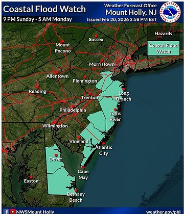 Minor to moderate flooding is expected at the shore and bayfront communities. (Courtesy of National Weather Service)


